Jaakko Heikka - Professional wilderness guide and diehard outdoor enthusiast with a special interest for lightweight backpacking, arctic expeditions and outdoor photography.

For more pictures, visit my gallery
In collaboration with…

– my personal views on all walks of outdoor life
This is “one from the archives” i.e. one of those trips I did but haven’t written about. But it was such a nice trip, it deserves to be blogged about and I thought now would be a good time since I’m again on my way to the same area…

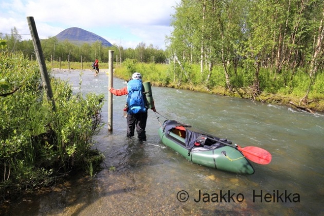
Last year I was guiding a packrafting trip to Reisadalen and as I had some free time before that, I decided to go for a quick stroll around the Käsivarsi Wilderness area. I had very rough plan of walking first to East, then up North and at the end returning to Kilpisjärvi. A simple trip without several kilos of packrafting, glacier travel or polar bear safety kit was a welcome change. Just a simple hike with light gear: HMG backpack, minimalistic tarp, “fancy feast” stove, etc. I even left the DSLR home in favour of a lighter point-and-shoot. So, here’s the story from that simple walk:
I arrive to the luttle village of Kilpisjärvi late in the afternoon on Sunday 30.8. I shoulder the delightfully light pack and start walking along the trail towards Terbmisjärvi hut. I had hoped to have a full day of hiking but work commitments turnnit into only a few hours of daylight.

The walking is easy, though my mind is still wandering and occasionally I stumble on the worn and rocky path. It’s quite warm for the final days of August this far North. There are some bugs along the birch woods and I wonder if it was a mistake not to pack the headnet and repellent. But usually you don’t need them this time of the year and once I get out from the bush to the higher ground the bugs are gone and won’t be bothering me again.
The 16km walk takes little over three hours and I’m pitching my tarp in good time near the Terbmisjärvi hut. The open hut would be empty but I want to see if the minimalistic 3×1,5m tarp actually works for me in open terrain. And with tarp you are way more connected to your surroundings than while in a tent or hut. I cook dinner, enjoy a beautiful moon rise and later admire an owl who soars around my tarp silently and gracefully.


I woke up to a drizzle the next morning. The tiny tarp has kept me dry and I’m ready for a new day, even if it seems to be a grey one. With minimal gear the morning chores take very little time and I’m on my way around 08:30.
I had planned to follow the valley East and then up thru Kutturakuru pass but with the light pack I’m tempted to head straight over the peak of Jollanoavi (1023m). On my way up I play hide-and-seek with a curious stoat (Mustela erminea) before reaching the summit. The clouds mess the views but it’s still nice to be on top of a big hill. It always is. I head down and meet two hikers who by coinsidense happen to be fellow bloggers Mari and Markus. A small world.


At lake Japmajavri the sun finds it’s way through the clouds and the views open. It’s beautiful, quiet and I have that good solitary feeling you get from traveling thru remote wilderness. I make a little detour North-East to wade across the Poroeno river from a safe place. Easy but long and cold crossing. Once my feet are warm again I stop for a coffee break. It’s close to 18:00 and this is the first proper break of the day but why stop if you are feeling good walking?

Bad bush steers me closer to Valtijoki and I can see my course crossing with a tent pitched on the river bank. I’m not really in the mood for meeting other people but prefer dry feet and easy going over solitude. At he campsite I meet a man who is half-way into his four week solo trip – without food! Instead of food he has a flyfishing kit snd plenty of spices. He has been fishing and foraging for over two weeks and seems to be living his dream: There’s an aura or satisfaction and happiness, and a constant smile. After a longish chat I continue up the Valtijoki feeling happy for meeting the man.
Valtijoki is a beautiful creek and there’s a good trail following it on the sand ridge. As expected, the waterlevel is a lot lower than the last time I was here with a packraft in July 2011. Around 21:00 I find a good spot to camp. There’s some dead wood by the river so I make a small fire to cook dinner and decide to cowboy camp by the river without the tarp. Close to midnight it starts to rain and I find myself hastly setting up the tarp in the dark with a headlamp. Would’ve been a lot easier to do it in the evening… Once under the tarp I fall asleep to the sound of water rushing over the rocky drops of Valtijoki. Over 31 kilometers off-trail in a day makes falling asleep easy but I wake up a few times being cold and adding layers. Apparently the long day has also eaten into my energy reserves.


In the morning the sun starts to warm my black sleeping bag and I sleep well past the alarm and wake up around 09:00. Two hours later than planned! There’s a damn cold wind straight from the North but otherwise the weather is nice. I continue up along the Valtijoki. The scenery is great and there would be plenty of excellent camp sites. After crossing the river I head to the open Kopmajoki hut for a coffee break. I meet a lone hiker with fishing kit on a two-week tour. Only few people wander in the remote parts of Käsivarsi and those who do, seem to be going solo, on a longer trips and often fishing…

From the hut I decide to hike up to the Ritnicohkka (1317m) which is actually the highest peak in Finland. The highest point of Finland is merely a point on the slope of the Halti fjell with the peak itself situated on the Norwegian side of the border. I follow the wide ridge from stellite peak Ritninolka and in the end have to scramble through some steeper slopes. I walk thru a barren landscape of grey rock and over patches of white snow. I sit down, admire the views to North-East and really enjoy being up there. Little later I’m on the summit in the jaws of the relentless wind. Everything is frozen, the temperature is well below zero and the wind feels very cold. I put on my puffy jacket and seek shelter behind the shed on the top and have a little break taking photos and sending a text message back home.


From Ritnicohkka I continue towards the actual summit of the Raisduottarhaldi (1361m), some two kilometeres to North and into Norway from the highest point of Finland. There’s a funny squeeky sound coming from my kit which I can’t localize despite checking my kit for stowaway lemmings. Soon the clouds roll in making navigation difficult and hiding the views. I adjust plans accordingly and head a bit more to the West until I meet the trail leading to the highest point of Finland (1323m) and walk up there to sign the book. No point of going for the actual summit. Near the border cairn there’s a book with a running number for visitors. Even though it’s not exact it gives an idea of the popularity: my number this time is 120066. The last time I was up here was in 2008 and then my number was 91203. Around 30000 vitits in the last eight years.

It’s still humid and cold and the wind is blowing. I hurry down from Halti to reach the open huts in the valley before darkness falls. The cozy old little hut seems to be empty so I head there. I really like it. It’s one of my favourite wilderness huts. And as the cold wind keeps on blowing, I’m happy to spend the night inside instead of sheltering under the bit-too-small-for-me-but-very-light tarp. I fetch water from the stream, light a fire in the stove and light the candle I brought with me and settle in while rain patters the single window. It’s warm and cozy inside. This night I don’t mind being little less connected to my surroundings.
Going thru my gear in the warm hut I find a reason for the weird squeeky sound that started while descenting Ritnicohkka: the soles of my trail runners are vetically broken between the heal and ball of the feet. They are worn and beaten anyway so it’s not a surprise but it means that for the return journey, I’ll stay on the trail in case of a catastrophic failure.
I don’t sleep too well. The hut feels too warm and the wooden platform feels hard as I only brought a thin short pad to save weight. Despite the discomfort I sleep until 09:00. Apparently I’m tired from the long days of walking. After morning chores I’m ready for the final 50km walk to Kilpisjärvi. I have an idea of walking it all in a one go as the trail is reasonably easy to follow even in the dark. My legs feel stiff and tired but soon pick up the rythm and I enjoy the downhill walk in the sunshine. Weather is good, views are good and going is easy. No reason not to enjoy.

Around midday I arrive to Pitsusjärvi hut. There’s a man sitting outside on the porch and he greets me with a question: “Do you have cell phone coverage?” It turns out his knees are in bad shape and he’d like to fly our with a float plane but doesn’t have signal to make the call. His brother is up on the nearby hill searching for signal. There’s no phone coverage in the valley but luckily I happen to have my satellite phone with me. I have it for guiding remote ski expeditions and don’t usually carry it on summer trips in Scandinavia but decided to take it with me this time. A happy coinsidence.
We wait until the second man returns from the hill. He didn’t have any luck of getting signal so we make series of calls first asking for the number of the floatplane service and then trying several times before getting thru. I have plenty of time to eat snacks and drink coffee.
Almost two hours later I depart from the hut and from the Southern end of the Pitsusjärvi lake I can see a small plane approaching the hut and landing near the shore. I’m not too happy for loosing nearly two hours of daylight but I’m happy that I could help some fellow hikers in need. I guess my concentration is not at it’s best as I walk off from the trail and miss a bridge. A mistake I’ve made also back in 2008 in the same place. I backtrack, cross the bridge and blaze down the trail towards South and Kilpisjärvi.

Near the mighty cliffs of Meekonpahta I notice a lonely rucksack on the side of the trail. I look around but can’t see anyone. I assume someone has left it there to visit a nearby summit. There’s a short section of duckboards which makes going fast and easy and I soon catch up with a group of four hikers. One of the group is not wearing a backpack but is insted wrapped in emergency blanket.
Soon I find out that she had slipped and broken her wrist and they are on their way back to the previous hut. We arrive to the Meekonjärvi hut in no time and I hear that someone has already headed higher to search for signal to make an emergency call. I offer to make a call with my satphone and call to the Emergency response center in Kerava, near Helsinki. They are first taken aback for me calling to them from Lapland but the normal 112 doesn’t work from a satphone… They reconnect me to the center in Oulu that oversees the Northern Finland and I get to know that a helicopter will be send to get the lady to hospital.
In less than an hour a Boarderguard helicopter arrives to the hut, lands nearby and the paramedics go in the hut to prepare the patient for the transfer. I chat with the pilots and the winch operator who seem to have really nice job. They were actually returning from another mission when being alerted here and that’s why they were so fast. After waving the helicopter goodbye I decide to utilize the little daylight that’s left by walking to the next hut.


The walking is incredibly good: The trail is easy. Views are good. The coolness and freshness of the dusk feel good. My feet are light and go on autopilot, the last 100 kilometers have thought them well. It’s already dark when I arrive to the hut so I decide to sleep inside. Instead of a mammoth 50 kilometer day I walked just the normal 30 km but this is how things roll.
The night in the hut was again too hot and the platform too hard. Beaten feet on hard wooden platform just doesn’t work. But in the morning I’m ready to continue and get the hike finished. I enjoy a lazy morning reading the guestbook before getting started with the final leg around 09:00. It’s cloudy and I don’t really care for the views. Instead I’m more interested in getting the boring trail walk finished.


There’s one more hut about midway to Kilpisjärvi and I have a coffee break there. I catch two hikers who left the previous hut earlier and they offer me some proper coffee, which is welcome change for the instant stuff I’ve been drinking. On my way to Kilpisjärvi I find few handfulls of ripe cloudberries and spy a willow grouse family in the birch woods for a while. Hiking on the worn trail feels dull and indifferent but when I arrive back to Kilpisjärvi I feel happy and tranquil. I remeber all the good feelings, the beautiful views and the solitude. There’s an aura of satisfaction and happiness.
A good hike.
– – –
In July I spent (again) a week on Kebnekaise area, this time combining two trips into a one-week tour. Both were traverses of a sort, the first including a traverse of the Kebnekaise summits and the second traversing the whole massif with packrafts. This post is about the latter.

The second part of the tour started after the third pint at the Fjällstation. The foundations of the trip being layed in the form of a pitched camp seven kilometers up to the Tarfala valley. So, fueled with the few pints me, Nina and Thomas started the walk back up to the alpine valley. With light packs it didn’t take too long. To lighten my load even further, I had left my rain gear in the camp so when the drops started to land on our shoulders, I sprinted to the camp while N and T stopped to put on their waterproofs.

After a midnight dinner it was time to hit the sack. We were little worried about Thomas’ hand which was slightly swollen and clearly very sore. But with the combined wisdom of two qualified WFRs we came to conclusion that nothing was likely broken and thus it didn’t need urgent attention and some “vitamin i” would suffice.
It wasn’t raining when we woke up but the rain started again while we were packing. And based on the weather forecast, it would rain heavily for the whole day. Good for the packrafting but less so for the walking. We hiked up the Tarfala valley, past the glaciers crawling down between the peaks hiding in the clouds. The end of the valley looks almost impassable but there is a decent path on the moraine ridge next to the Giebmebaktiglaciären.

As we ascended up from the valley the rain crew heavier and the wind picked up. Temperature was probably closer to 0°C than +5°C and with the wind-driven rain it would be a cold day. Before the pass there was a section of steep snow and having changed our boots, crampons and iceaxes to trail runners and paddles had to make due with what we had and be carefull not to take a long tumble-down into the glacial lake.
Up on the pass above 1400m it was even colder and we were soaked. I started to lose grip strength from my fingers, a typical thing for me in the cold, having to do chores by pushing my palms together instead of pinching with my fingers. I wanted to get down fast but N was starting to feel hypothermic and wanted to have a break instead. Luckily someone had cleared a small relatively spot for a tent between the rocks so we decided to have a proper break, pitched our tent and dived inside.

Sheltered by the thin nylon walls, me and Thomas added a layer and N changed into her dry sleeping clothes and drysuit, which was probably the smartest thing to do. Sitting in the tent battered by rain and gusts we watched walls flap and bellow and the little streams rush through the vestibule while enjoying our hot drinks and lunch. But once the stove was off, it wasn’t too warm in the tent either so it was time to get going.
Strengthened by the extra calories and layers we continued down in the steady rain through the land of snow and still partially frozen lakes. The terrain was mostly rocky but the long snow patches offered fun variation in the form of fast slides down, breaking and steering with the mid-sections of our four-piece-paddles. I’m sure the views from Guobirvaggi would’ve been great with decent weather but now we saw only the lower sections of the dark cliffs towering up towards the sky and occasional glimpse of the sharp summit of Gaskkasbakti.
After wading a fast flowing glacial river fattened by the rain we got to easier ground. I ate the last bar of the day to get sensation back to my cold feet and enjoyed the easier walking as rocks started to give away for tundra. Since we started late, we reached the Kungsleden around 20:00 and had to make a decision: camp near the Kuoperjåkka shelter or hike additional 7 kilometers upstream to Sälkastugorna huts. We could see several tents near the little shed downstream and there would be soft dry beds, a little shop and even sauna at Sälkastugorna so the decision was pretty easy.
We hiked up to the hut in 1 hours 40 minutes on the Kungsleden, one of the most famous trails in Scandinavia and thus very worn too. Unfortunately we weren’t fast enough to get to the sauna which was closed at 21:00 but cans of cola and warm dry beds felt about as good. When hanging our gear to dry I emptied half a cup of water from each of the chest pockets of my shell jacket. So much for waterproof zippers!
Knowing that there was also a liter or two of water in our tent from the lunch break, the dry and warm bed felt especially good.
I guess we all felt little beaten the next morning. We lied in long and watched other people come and go preparing breakfast and desperately waxing their 1000G trousers over the gas stove. After a breakfast and final cups of coffee we headed out dressed in our paddling clothing. Me and N had light Ursuk MPS drysuits while Thomas had opted to go with a thin wetsuit. I guess it’s quite rare to have people walking along the Kungsleden in full neoprene suit…
After a short walk to the river we inflated our rafts, scouted the river from a nearby hill and hit the waters of Tjäktjajåkka. Now the extra 7 kilos lugged over the mountains started to do the work and pay back. The river started with a section of rocky class 2 water with a couple of bigger waves but soon calmed down into fast and straight-forward class 1 ride.

At the first reindeer fence we got out and scouted the canyon-like S curve leading to a little bridge. N and Thomas decided to portage it while I paddled it without the rucksack on the bow. I’d estimate it was around class 3 due to big waves and thigh turns with a neat narrow gate in the end. Very beautiful spot along a river with great views.
It was cloudy with light showers of rain but great weather compared to the day before. Paddling was easy, fast and enjoyable. Very nice packrafting indeed. The MRS Alligator 2S performed well and the dry spray deck and excellent thigh straps were worth the extra kilo.

Closing into the next bridge we knew it was time to get out from the waters and portage based on the aerial photos on Lantmäteriet map service. The beginning looked like fun class 2-3 drops and waves but soon the river rushed into a deep, steep and narrow canyon suitable only for the maddest hard-shell white-water enthusiasts. We had a nice lunch break by the side and portaged along the Western shore past the waterfalls near the Sami village of Kårtjevuolle.


I played around a bit in the final drops enjoying another incredibly beautiful spot. This is how rivers should look like! But soon it was time to continue downstream.
At the end of the previous day we had scratched our original plan of packrafting all the way down to the Padje Kaitumjaure, then following the lake to East and bushwhacking over the fjells to Laddjujohka to paddle down to Nikkaluokta. After the long and wet day it felt like little too much. So instead we took out near the Unna Jiertas fjell and called it a day. There were many gravel banks suitable for camping and quite a bit of dry willow branches cut by the winter ice and left up to dry by the floods. This all translated into good camping grounds for packrafters.

We pitched our tent, spread our gear all over the place to dry in the wind and I bolted out to gather some dry branches for a campfire. For me, an evening by a campfire is essential part of a good packrafting adventure. Unfortunately it started to rain soon and instead of a nice evening by the fire, we spent it in our tent. But the tent and our gear was mostly dry so no real reason to complain.
The next morning we packed our still dripping wet rafting kit into our rucksacks and headed up to the trail towards the Kebnekaise Fjällstation. Despite the clouds, the views down to massive Tjäktavagge valley and around the alpine-like Jierttajavri lake were beautiful. The weather was the familiar mix of cloudy and windy with showers of rain but after the one very wet day, it didn’t feel too bad. Walking on the trail was pretty easy and driven by the promise of hot sauna and cold beer, we hiked the 15 kilometers in four hours or so with very few breaks.


In the afternoon we were again at the Fjällstation. We hadn’t planned it that way but it was welcome. Short and easy day, good coffee and sandwiches on soft sofas and sauna with a cold beer. Not too bad. I felt I could get used to doing trips like that. But not to take it too far, we opted not to have the three-course buffet dinner and also slept in our tent instead of the soft beds. In the late evening the temperature dropped to +4°C but we were warm crammed in our cozy little tent. The Anjan 3 is better for two but works also for three as planned.
Waking up to a cold but sunny dayfor an early start we got distracted by the excellent breakfast at the Fjällstation once and for all and sat there for an hour making up the calories lost during the previous days and downing several cups of good coffee. We were again dressed in our paddling gear and I’m sure many of the fellow guests would’ve liked to ask from the neoprene-clad Thomas what he was up to but politely refrained.
From the distance it had seemed that with the high water we could start paddling almost straight down from the Fjällstation so we walked about a kilometer down to the river. Here the river was more like a stream but seemed paddlable, rocky and fast but not impossibly shallow, so we inflated our rafts one final time and shot down the stream.
The river stayed small, shallow and fast down to the confluence of the Darfaljohka. It was difficult to avoid all the rocks but good paddling was rewarded with fast and splashy ride without getting stuck on the rocks. Down from the confluence the stream grew into milky.-coloured creek with occasional simple splashy class II sections. Simple and fun going!


Before Laddjujavri lake the river calms down into meandering bends with slow flow requiring a bit of actual paddling. We arrived to the little lake with an excellent backwind and decided to take a lazy ride sailing instead of paddling. I had thought about it already on the way and soon we had lashed our three packrafts side by side and rigged the tent fly to the front as a sail. Me and Thomas, sitting on the side, managed the sail while N was using her paddle as a rudder steering the raft. It worked really well! The lake is only about 2 kilometers long so paddling might had been more efficient time-wise, but this was more fun. We sailed straight to the shore where the locals offer boat rides for tourists to rest their feet and I’m sure baffled a few people again. But still, no-one dared to approach us. Next time, I’ll take a pirate flag too and see how it goes…

On the shore there is the legendary Lap Dånalds which was now closed and superseded by “Restaurang Enoks”. Judging from the upgrade, the reindeer burger business is doing well. Once again we surrendered for the temptations, walked in and offered the whole shebang: reindeer burgers, Cola, waffles and coffee. And oh boy, it was good again!


From the lake the nature of the river changes: It’s more like a proper river than a creek. With this water-level it was was almost a single constant class II rapid for the final five kilometers. The riverbed was littered with boulders from the size of a bucket up to size of a big refrigerator, there was often sweepers in the outer bends and occasional thigh S curve when the milky water had found a new way through a gravel bar. We went down eddy-hopping a section at a time me leading the way. During a longer more demanding section I got worried about how N would do and tried to stop mid-stream to have a look. Instead I hit a rock and capsized. Luckily I only hit my knee and was able to self-rescue easily in the shallow water. A stupid mistake reminding me that paying attention to the river is always primary and other worries secondary.
Near Nikkaluokta we arrived once again to a reindeer fence and got off from the river. This time it was not to portage around a dangerous section but for the final short walk and wade to our car which was waiting near the helipad. Six hours after launching our rafts we had paddled 19 kilometers down to Nikkaluokta. With stomachs still full of burgers and other treats we loaded the car and started the long drive South.
The latter part of the trip didn’t go quite as planned but was very enjoyable, maybe except for the wet and cold first day. Should the weather been better we might have done the loop as planned but then we would’ve missed quite a bit of the paddling from Laddjujohka, which was great fun. But I guess I’ll have to return there again one day to explore the lower Tjäktajåkka and many other interesting looking rivers. There’s a lot to paddle on the area!
A word about the rivers near Kebnekaise:
The rivers on the Kebnekaise area are mountain rivers with some creek-like sections. The water-level can change rapidly and you need reasonable level to make good packrafting. See for example SMHI Vattenweb for simulated flow estimates. Based on the Vattenweb we had over 20 sqm/s at the put in of the Tjäktjajåkka and little less at the lower Laddjujohka. Thanks to the heavy rain, both rivers were clearly above the normal summer level. Probably half of the flow would be enough for good packrafting and more might make it challenging in places. I would recommend going earlier in the season to catch the end of the spring flood or waiting for rain to get proper flow. Anyway, one should pay attention to the planning and make sure to avoid the seriously dangerous sections (consult aerial photos for that) and if planning to do whitewater, have the proper gear, skills and company.
The scenery is magnificent, the rivers are beautiful and the packrafting is fun, but remember to be careful!
In July I spent (again) a week on Kebnekaise area, this time combining two trips into a one-week tour. Both were traverses of a sort, the first including a traverse of the Kebnekaise summits and the second traversing the whole massif. This post is about the first one involving crampons but no packrafts.

The go-to summer-holiday kit in and around the go-to backpack.
The first part of the tour was a three-day glacier travel and climbing trip with Ankarat avotunturit guides. The idea being training and exchanging knowledge and skills – and of course climbing the mountain, should the weather permit.
After a long drive and short sleep our group of three (me, Nina and Thomas) woke up to a blue skies and sunshine in our tent near Nikkaluokta, drove the final kilometers and met the rest of the group at the heliport.
We had chosen to fly in instead of walking to make out most of the limited time. My HMG Porter pack felt heavy and when the scale showed 33kg, I wasn’t too surprised. This wans’t an UL trip. Even though most of my kit was light, I had my share of the heavy “workhorse” climbing kit, heavyish packrafting kit and some fresh food as we were flying in anyway…

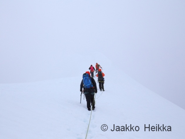
After a very short flight (instead of a day’s walk) we landed on the Storgläcieren, pitched base camp, had early lunch – which was very welcome, as I had missed breakfast. Then we roped up and headed on the slopes to train some individual and rope-team techniques. It was a beautiful sunny day on the glacier ending with a hearty pasta dinner and red wine. Somehow climbing and red wine go well together…


The next morning was equally beautiful and seemed good for climbing the mountain. The snow is always slushy under the 24-hour Arctic summer sun so instead of an alpine start we headed out around 9.00 after a proper breakfast including coffee, fruits, fresh bread, scrambeled eggs and so on. Flying in has it’s advantages.
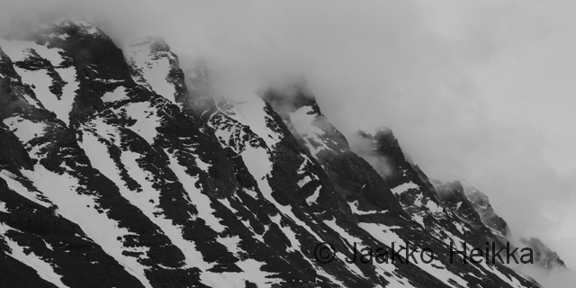
First we crossed the glacier and then climbed up the steep snow slope leading to the Halspasset pass. The sun was hammering us on the climb but we could see clouds speeding thru the pass from the West promising a change in the weather. After a break, sheltered behind some rock to get out from the wind, we continued up towards the Nordtoppen scrambling and climbing some easy rock. There were old pitons for protection but they required quite a bit of hammering to feel somewhat secure. As the climb was easy we used them as running protection to make climbing faster and easier.


Towards the top the weather closed in: cloudy, windy and cold. No views. But after a short walk over some snow and rocks we reached the Nordtoppen! 2096,8 meters of rock, soon to be the highest peak in Sweden. On the top we roped up again for the ridge-walk to the Sydtoppen. The ridge is quite narrow and airy but without seeing the drop on left and right, it didn’t feel too special. Soon we reached the Sydtoppen (2097,5m) which still is the highest peak in Sweden, but will likely loose its status as the snow melts as the climate warms.

There are some huts near the summit (and apparently they were building new huts even closer to the summit?) where we had our second lunch-break before descenting down the via ferrata style Östraleden. As usual, the weather was bad only near the summit and on the way down we started to see the views again: the surrounding mountains and the tempting curves of the river we would be packrafting a few days later… The Östraleden was very nice climb/scramble with via ferrata style safety making going fast, safe and easy. Down on the glacier we roped up again and reached our camp about 12 hours after the start.


After securing a near run-away TNF VE25, more pasta and red wine was on the menu. (It was a windy day! And the tent was pitched with three parachute-style deadman anchors and was flapping sideways in the wind only one left when we arrived…)

The third and final day was again sunny and warm. We spent the first half of the day training crevasse rescue techniques, then broke camp and headed down. As the wine, beer and fresh food were mostly gone my pack didn’t weight 33kg anymore but it still felt heavy with 50 meters of wet rope making up the difference in food weight.

Once we got down from the glacier and moraine me, Nina and Thomas set camp to the valley and went through our gear once more as we would continue for our packrafting trip. But before heading further, we would lighten our loads by taking all the unnecessary climbing (and comfort) gear down to the Fjällstation to be flown out on the sheduled daily helicopter flights. The Fjällstation was in opposite direction but lighter packs would be worth the walk. And there would be beer too…

The 7km downhill walk on the trail took around two hours and a duffel of gear was paid and handed over fast but somehow the beers and soft sofas allured us to stay little longer. You know, it’s only one beer… And maybe second. Oh, you brought a third? Well, why not.

The second trip, a packrafting tour around Kebnekaise massif, would start from here.
In June me and N traversed Kebnekaise (2100m or so), the highest peak of Sweden. It’s a classic hike with parts following the wide path from Nikkaluokta to Kebnekaise Fjällstation and parts following the hugely popular Kungsleden trail. The marked trails and well equipped huts can make a nice hike in spectacular Alpine scenery. But I seem to be incapable of going “only” for a nice walk.

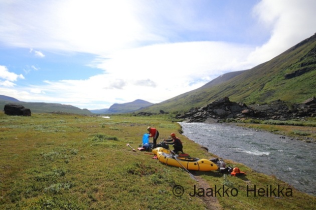
Instead I usually come up with a stupidly big unconventional plans. This time the plan was to start from Nikkaluokta, hike over the Kebnekaise (1700 vertical meters mostly with huge backpacks), then head further North to packraft river Aliseatnu (no idea if you can paddle it but looks reasonable on aerial photos) and then hike back Southward to float the Visttasjohka river back to the car. Pretty awesome plan, eh?
To enjoy good flows for packrafting going early in the season is good idea but this year summer was seriously late which meant plenty of snow on the trail (snowshoes needed), cold nights (a bit more insulation) and cold, fast and bloated rivers on the week after the summer solstice. Not far away people were still skiing and driving snow scooters… As you can guess, with these conditions it doesn’t always go as planned.

After a late camp, approach from Nikkaluokta and a great breakfast at the Fjällstation N was the sound of reason and said that hiking up the “Västra leden” (Western route to Kebnekaise) with 25kg backpacks was a stupid idea. Well, it probably was. So instead we traversed to the Eastern side of the mountain. Scratch the original plan, but there was a backup…

The highway on the approach from Nikkaluokta to the Fjällstation.

It would’ve been up that way and over the peak in the middle and then to the actual summit…

The next day we tried to approach the summit from East along “Durlins led” but we started too late and sinking into the wet snow with our snowshoes, watching the cornices rumble down from the cliffs on both sides N pulled the plug again and we returned to camp. No summit this time. Probably a good decision.


I’ve read that Singgivaggi has good campsites by the lakes… What lakes?

And judging from the still frozen lakes and stories told by other hikers we met on the trail, packrafting the Ailiseatnu river would probably not work either: the lakes would still be covered with ice and river probably too dangerous due ice and flooding. So scratch that too. Instead we hiked a short day to Sälkastugorna huts and solaced ourselves with some extra rations from the small shop, a sauna and soft beds. Not a bad way of spending a holiday either but why do the conventional option when you can try an unconventional one?

The next day we decided to take a shortcut to Visttasvaggi valley through Stuor Reiddavaggi valley and past the majestetic mountain Njallu. We ended up walking most of the way on snowshoes hauling packrafts as sleds but we didn’t mind as it worked really well. The rain and clouds hid some of the scenery a bit but it was still beautiful.

Proper winter in Stuor Reiddavaggi in late June.

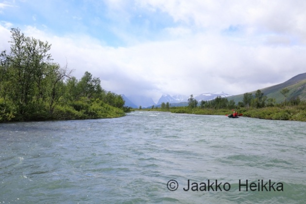
The next day we started with a short day hike upstream from Visttasstuga hut to packraft the upper part of Visttasjohka river. The river was in full flood being faster and slightly more demanding than I had thought but not too difficult. With the silty water rock contacts were unavoidable but swift and harmful. At the hut we packed the rest of our kit on the rafts and headed downstream.

N floating on the upper parts of Visttasjohka.

I knew the river would be quite easy from Nikkaluokta up to Lisa’s stuga and from the aerial photos I had noticed only one serious section of white water on the way to Lisa’s stuga. (It’s where the trail from Kaskasvagge crosses the river. Serious stuff.) Well, with the flood there were more difficult spots and in the strong current without any eddies we ended up to a section of big waves in a rocky bend. I’d say it was class 3 or so, not extremely difficult but too difficult for N who capsized and while I was checking on her I flipped too. After some time with rocks hitting my legs I decided a wet re-entry wouldn’t be good idea and swam ashore with my kit. N had manged to get to the shore as well so I paddled down stream to catch her raft. A moment later we were together on the shore, little bruised and scared but in one piece and with all our kit. N wasn’t any more in the mood for packrafting so I continued alone down to the bridge and from there on we hiked down to Lisa’s cabin, passing what seemed like excellent packrafting.


Part of the serious stuff after the bridge.
 The next day we paddled down from Lisa’s stuga to Nikkaluokta in great weather and with great speed: good flow and some back-wind plus a closing cafeteria helps a lot. In the end we did 9 kilometers (measured on map along the river) in 1 hour 25 minutes. That might be the fastest packrafting I’ve ever done if not counting short sections of rapids. With numb legs we stumbled towards the parking area and well deserved coffee and cake.

Lisa’s stuga: cozy open cabin with interesting history. Bring your own firewood.

You know it’s good when you have snowshoes and packraft.
For most of the week the weather was great and favourable but conditions were against us and maybe we just weren’t up to the task. I guess no one likes scratching but if you plan huge and fail, you can still deliver big. So it wasn’t a bad trip, and one day I might try it again with the “racing style” required to pull it through.
– – –
As usual, more photos in my gallery!
– – –
A footnote on packrafting the Visttasjohka:
If you are planning to packraft the Visttasjohka river, I’d recommend going with high water but after the floods of the spring this will vary between years. With the floods eddies are very few which makes either long scouting walks or committed paddling. If you start lower, you’ll need less water.
Study the aerial photos carefully and at minimum scout the section starting before the bridge mentioned above. And if you’re planning to paddle it, take proper white water kit. Also the bend about 2,4km upstream from the bridge (where we capsized) and the spot were Kaskasjohkka joins the Visttasjohkka are worth scouting, at least when water level is high.
The river drops 120 meters on 17,5 kilometers from the source to Lisa’s stuga and 40 meters on the 22,5km from Lisa’s to Nikkaluokta so speed is guaranteed if waterlevel is adequate. The river offers great packrafting but be carefull, we are not the only ones who have swum there.
This is again a bilingual blog post about guiding services I am offering. / Tämä on jälleen kaksikielinen tiedote tarjoamistani opaspalveluista.
This post is also to serve as a “commenting area” as the comments on pages are disabled. / Tämä tiedote palvelee myös kommentointi- ja keskustelualueena, sillä info-sivuilla ei voi kommentoida.

Templet, Svalbard. Would you like to go there? You can join me for expedition in April 2015!
– – –
Templet, Huippuvuoret. Haluaisitko sinne? Lähde mukaan retkikuntaan huhtikuussa 2015!
My winter 2015 will be mostly spent guiding for the Ankarat avotunturit ski expedition program. In 2015 the program offers selection of short courses, one-week ski tours and longer ski expeditions to the fjells of Lapland, to Vatnjakökull the largest glacier in Europe and to the cold shores and jagged peaks of Svalbard. And if you dare, you can join us on these memorable trips!
Most of the programs will be guided in Finnish only but we have a tailor-made, all-in-one program guided in English: The Crash Course in the Arctic Expeditions (click for more information)!
I will be personally guiding set of trips. As said the main language will be Finnish but except for the introductory courses you can get away with very basic understanding of Finnish and we can discuss things in English in addition.
More information available on the Ankarat avotunturit website but again in Finnish only.
Tailor made programs in English are also available on request.
If interested, please ask for details with e-mail!

Talvi 2015 kuluu pääosin Anrakat avotunturit -koulutusohjelman kurssien, vaellusten ja retkikuntien toteuttamisessa. Suuntana ovat siis pohjoisen jylhät tunturialueet, Euroopan suurin jäätikkö Islannissa sekä Huippuvuorten kylmät rannat ja terävät huiput. Ja myös sinun on mahdollista lähteä mukaan matkaan!
Minut saa oppaakseen ainakin seuraavilla kursseilla, vaelluksilla ja retkikunnissa. Ja todennäköisesti olen mukana myös monilla muilla kursseilla.
Katso myös tiedot muista kursseista ja vaelluksista www.avotunturit.fi sivuilta! Olen mukana mm. useilla erikoiskursseilla.
Minun lisäkseni Ankarat avotunturit -koulutusohjelman kursseja pyörittävät Kari “Vaiska” Vainio ja Carissa “ADQ” Lehtolainen. Mikäli minun tarjoamani päivämäärät eivät sovi kalenteriisi tai joku toinen kohde kiinnostaisi enemmän, katso muu tarjonta Ankarat avotunturit -sivuilta!

Nordic nature at its best!
– – –
Pohjoisen luontoa parhaimmillaan!
Jaakko Heikka - Professional wilderness guide and diehard outdoor enthusiast with a special interest for lightweight backpacking, arctic expeditions and outdoor photography.
For more pictures, visit my gallery
