Jaakko Heikka - Professional wilderness guide and diehard outdoor enthusiast with a special interest for lightweight backpacking, arctic expeditions and outdoor photography.

For more pictures, visit my gallery
In collaboration with…
– my personal views on all walks of outdoor life
This is “one from the archives” i.e. one of those trips I did but haven’t written about. But it was such a nice trip, it deserves to be blogged about and I thought now would be a good time since I’m again on my way to the same area…

Last year I was guiding a packrafting trip to Reisadalen and as I had some free time before that, I decided to go for a quick stroll around the Käsivarsi Wilderness area. I had very rough plan of walking first to East, then up North and at the end returning to Kilpisjärvi. A simple trip without several kilos of packrafting, glacier travel or polar bear safety kit was a welcome change. Just a simple hike with light gear: HMG backpack, minimalistic tarp, “fancy feast” stove, etc. I even left the DSLR home in favour of a lighter point-and-shoot. So, here’s the story from that simple walk:
I arrive to the luttle village of Kilpisjärvi late in the afternoon on Sunday 30.8. I shoulder the delightfully light pack and start walking along the trail towards Terbmisjärvi hut. I had hoped to have a full day of hiking but work commitments turnnit into only a few hours of daylight.

The walking is easy, though my mind is still wandering and occasionally I stumble on the worn and rocky path. It’s quite warm for the final days of August this far North. There are some bugs along the birch woods and I wonder if it was a mistake not to pack the headnet and repellent. But usually you don’t need them this time of the year and once I get out from the bush to the higher ground the bugs are gone and won’t be bothering me again.
The 16km walk takes little over three hours and I’m pitching my tarp in good time near the Terbmisjärvi hut. The open hut would be empty but I want to see if the minimalistic 3×1,5m tarp actually works for me in open terrain. And with tarp you are way more connected to your surroundings than while in a tent or hut. I cook dinner, enjoy a beautiful moon rise and later admire an owl who soars around my tarp silently and gracefully.


I woke up to a drizzle the next morning. The tiny tarp has kept me dry and I’m ready for a new day, even if it seems to be a grey one. With minimal gear the morning chores take very little time and I’m on my way around 08:30.
I had planned to follow the valley East and then up thru Kutturakuru pass but with the light pack I’m tempted to head straight over the peak of Jollanoavi (1023m). On my way up I play hide-and-seek with a curious stoat (Mustela erminea) before reaching the summit. The clouds mess the views but it’s still nice to be on top of a big hill. It always is. I head down and meet two hikers who by coinsidense happen to be fellow bloggers Mari and Markus. A small world.


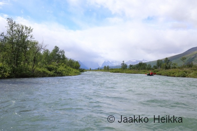
At lake Japmajavri the sun finds it’s way through the clouds and the views open. It’s beautiful, quiet and I have that good solitary feeling you get from traveling thru remote wilderness. I make a little detour North-East to wade across the Poroeno river from a safe place. Easy but long and cold crossing. Once my feet are warm again I stop for a coffee break. It’s close to 18:00 and this is the first proper break of the day but why stop if you are feeling good walking?

Bad bush steers me closer to Valtijoki and I can see my course crossing with a tent pitched on the river bank. I’m not really in the mood for meeting other people but prefer dry feet and easy going over solitude. At he campsite I meet a man who is half-way into his four week solo trip – without food! Instead of food he has a flyfishing kit snd plenty of spices. He has been fishing and foraging for over two weeks and seems to be living his dream: There’s an aura or satisfaction and happiness, and a constant smile. After a longish chat I continue up the Valtijoki feeling happy for meeting the man.
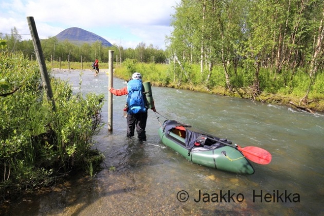
Valtijoki is a beautiful creek and there’s a good trail following it on the sand ridge. As expected, the waterlevel is a lot lower than the last time I was here with a packraft in July 2011. Around 21:00 I find a good spot to camp. There’s some dead wood by the river so I make a small fire to cook dinner and decide to cowboy camp by the river without the tarp. Close to midnight it starts to rain and I find myself hastly setting up the tarp in the dark with a headlamp. Would’ve been a lot easier to do it in the evening… Once under the tarp I fall asleep to the sound of water rushing over the rocky drops of Valtijoki. Over 31 kilometers off-trail in a day makes falling asleep easy but I wake up a few times being cold and adding layers. Apparently the long day has also eaten into my energy reserves.


In the morning the sun starts to warm my black sleeping bag and I sleep well past the alarm and wake up around 09:00. Two hours later than planned! There’s a damn cold wind straight from the North but otherwise the weather is nice. I continue up along the Valtijoki. The scenery is great and there would be plenty of excellent camp sites. After crossing the river I head to the open Kopmajoki hut for a coffee break. I meet a lone hiker with fishing kit on a two-week tour. Only few people wander in the remote parts of Käsivarsi and those who do, seem to be going solo, on a longer trips and often fishing…

From the hut I decide to hike up to the Ritnicohkka (1317m) which is actually the highest peak in Finland. The highest point of Finland is merely a point on the slope of the Halti fjell with the peak itself situated on the Norwegian side of the border. I follow the wide ridge from stellite peak Ritninolka and in the end have to scramble through some steeper slopes. I walk thru a barren landscape of grey rock and over patches of white snow. I sit down, admire the views to North-East and really enjoy being up there. Little later I’m on the summit in the jaws of the relentless wind. Everything is frozen, the temperature is well below zero and the wind feels very cold. I put on my puffy jacket and seek shelter behind the shed on the top and have a little break taking photos and sending a text message back home.


From Ritnicohkka I continue towards the actual summit of the Raisduottarhaldi (1361m), some two kilometeres to North and into Norway from the highest point of Finland. There’s a funny squeeky sound coming from my kit which I can’t localize despite checking my kit for stowaway lemmings. Soon the clouds roll in making navigation difficult and hiding the views. I adjust plans accordingly and head a bit more to the West until I meet the trail leading to the highest point of Finland (1323m) and walk up there to sign the book. No point of going for the actual summit. Near the border cairn there’s a book with a running number for visitors. Even though it’s not exact it gives an idea of the popularity: my number this time is 120066. The last time I was up here was in 2008 and then my number was 91203. Around 30000 vitits in the last eight years.

It’s still humid and cold and the wind is blowing. I hurry down from Halti to reach the open huts in the valley before darkness falls. The cozy old little hut seems to be empty so I head there. I really like it. It’s one of my favourite wilderness huts. And as the cold wind keeps on blowing, I’m happy to spend the night inside instead of sheltering under the bit-too-small-for-me-but-very-light tarp. I fetch water from the stream, light a fire in the stove and light the candle I brought with me and settle in while rain patters the single window. It’s warm and cozy inside. This night I don’t mind being little less connected to my surroundings.
Going thru my gear in the warm hut I find a reason for the weird squeeky sound that started while descenting Ritnicohkka: the soles of my trail runners are vetically broken between the heal and ball of the feet. They are worn and beaten anyway so it’s not a surprise but it means that for the return journey, I’ll stay on the trail in case of a catastrophic failure.
I don’t sleep too well. The hut feels too warm and the wooden platform feels hard as I only brought a thin short pad to save weight. Despite the discomfort I sleep until 09:00. Apparently I’m tired from the long days of walking. After morning chores I’m ready for the final 50km walk to Kilpisjärvi. I have an idea of walking it all in a one go as the trail is reasonably easy to follow even in the dark. My legs feel stiff and tired but soon pick up the rythm and I enjoy the downhill walk in the sunshine. Weather is good, views are good and going is easy. No reason not to enjoy.

Around midday I arrive to Pitsusjärvi hut. There’s a man sitting outside on the porch and he greets me with a question: “Do you have cell phone coverage?” It turns out his knees are in bad shape and he’d like to fly our with a float plane but doesn’t have signal to make the call. His brother is up on the nearby hill searching for signal. There’s no phone coverage in the valley but luckily I happen to have my satellite phone with me. I have it for guiding remote ski expeditions and don’t usually carry it on summer trips in Scandinavia but decided to take it with me this time. A happy coinsidence.
We wait until the second man returns from the hill. He didn’t have any luck of getting signal so we make series of calls first asking for the number of the floatplane service and then trying several times before getting thru. I have plenty of time to eat snacks and drink coffee.
Almost two hours later I depart from the hut and from the Southern end of the Pitsusjärvi lake I can see a small plane approaching the hut and landing near the shore. I’m not too happy for loosing nearly two hours of daylight but I’m happy that I could help some fellow hikers in need. I guess my concentration is not at it’s best as I walk off from the trail and miss a bridge. A mistake I’ve made also back in 2008 in the same place. I backtrack, cross the bridge and blaze down the trail towards South and Kilpisjärvi.

Near the mighty cliffs of Meekonpahta I notice a lonely rucksack on the side of the trail. I look around but can’t see anyone. I assume someone has left it there to visit a nearby summit. There’s a short section of duckboards which makes going fast and easy and I soon catch up with a group of four hikers. One of the group is not wearing a backpack but is insted wrapped in emergency blanket.
Soon I find out that she had slipped and broken her wrist and they are on their way back to the previous hut. We arrive to the Meekonjärvi hut in no time and I hear that someone has already headed higher to search for signal to make an emergency call. I offer to make a call with my satphone and call to the Emergency response center in Kerava, near Helsinki. They are first taken aback for me calling to them from Lapland but the normal 112 doesn’t work from a satphone… They reconnect me to the center in Oulu that oversees the Northern Finland and I get to know that a helicopter will be send to get the lady to hospital.
In less than an hour a Boarderguard helicopter arrives to the hut, lands nearby and the paramedics go in the hut to prepare the patient for the transfer. I chat with the pilots and the winch operator who seem to have really nice job. They were actually returning from another mission when being alerted here and that’s why they were so fast. After waving the helicopter goodbye I decide to utilize the little daylight that’s left by walking to the next hut.


The walking is incredibly good: The trail is easy. Views are good. The coolness and freshness of the dusk feel good. My feet are light and go on autopilot, the last 100 kilometers have thought them well. It’s already dark when I arrive to the hut so I decide to sleep inside. Instead of a mammoth 50 kilometer day I walked just the normal 30 km but this is how things roll.
The night in the hut was again too hot and the platform too hard. Beaten feet on hard wooden platform just doesn’t work. But in the morning I’m ready to continue and get the hike finished. I enjoy a lazy morning reading the guestbook before getting started with the final leg around 09:00. It’s cloudy and I don’t really care for the views. Instead I’m more interested in getting the boring trail walk finished.


There’s one more hut about midway to Kilpisjärvi and I have a coffee break there. I catch two hikers who left the previous hut earlier and they offer me some proper coffee, which is welcome change for the instant stuff I’ve been drinking. On my way to Kilpisjärvi I find few handfulls of ripe cloudberries and spy a willow grouse family in the birch woods for a while. Hiking on the worn trail feels dull and indifferent but when I arrive back to Kilpisjärvi I feel happy and tranquil. I remeber all the good feelings, the beautiful views and the solitude. There’s an aura of satisfaction and happiness.
A good hike.
– – –
In July I spent (again) a week on Kebnekaise area, this time combining two trips into a one-week tour. Both were traverses of a sort, the first including a traverse of the Kebnekaise summits and the second traversing the whole massif with packrafts. This post is about the latter.

The second part of the tour started after the third pint at the Fjällstation. The foundations of the trip being layed in the form of a pitched camp seven kilometers up to the Tarfala valley. So, fueled with the few pints me, Nina and Thomas started the walk back up to the alpine valley. With light packs it didn’t take too long. To lighten my load even further, I had left my rain gear in the camp so when the drops started to land on our shoulders, I sprinted to the camp while N and T stopped to put on their waterproofs.

After a midnight dinner it was time to hit the sack. We were little worried about Thomas’ hand which was slightly swollen and clearly very sore. But with the combined wisdom of two qualified WFRs we came to conclusion that nothing was likely broken and thus it didn’t need urgent attention and some “vitamin i” would suffice.
It wasn’t raining when we woke up but the rain started again while we were packing. And based on the weather forecast, it would rain heavily for the whole day. Good for the packrafting but less so for the walking. We hiked up the Tarfala valley, past the glaciers crawling down between the peaks hiding in the clouds. The end of the valley looks almost impassable but there is a decent path on the moraine ridge next to the Giebmebaktiglaciären.

As we ascended up from the valley the rain crew heavier and the wind picked up. Temperature was probably closer to 0°C than +5°C and with the wind-driven rain it would be a cold day. Before the pass there was a section of steep snow and having changed our boots, crampons and iceaxes to trail runners and paddles had to make due with what we had and be carefull not to take a long tumble-down into the glacial lake.
Up on the pass above 1400m it was even colder and we were soaked. I started to lose grip strength from my fingers, a typical thing for me in the cold, having to do chores by pushing my palms together instead of pinching with my fingers. I wanted to get down fast but N was starting to feel hypothermic and wanted to have a break instead. Luckily someone had cleared a small relatively spot for a tent between the rocks so we decided to have a proper break, pitched our tent and dived inside.

Sheltered by the thin nylon walls, me and Thomas added a layer and N changed into her dry sleeping clothes and drysuit, which was probably the smartest thing to do. Sitting in the tent battered by rain and gusts we watched walls flap and bellow and the little streams rush through the vestibule while enjoying our hot drinks and lunch. But once the stove was off, it wasn’t too warm in the tent either so it was time to get going.
Strengthened by the extra calories and layers we continued down in the steady rain through the land of snow and still partially frozen lakes. The terrain was mostly rocky but the long snow patches offered fun variation in the form of fast slides down, breaking and steering with the mid-sections of our four-piece-paddles. I’m sure the views from Guobirvaggi would’ve been great with decent weather but now we saw only the lower sections of the dark cliffs towering up towards the sky and occasional glimpse of the sharp summit of Gaskkasbakti.
After wading a fast flowing glacial river fattened by the rain we got to easier ground. I ate the last bar of the day to get sensation back to my cold feet and enjoyed the easier walking as rocks started to give away for tundra. Since we started late, we reached the Kungsleden around 20:00 and had to make a decision: camp near the Kuoperjåkka shelter or hike additional 7 kilometers upstream to Sälkastugorna huts. We could see several tents near the little shed downstream and there would be soft dry beds, a little shop and even sauna at Sälkastugorna so the decision was pretty easy.
We hiked up to the hut in 1 hours 40 minutes on the Kungsleden, one of the most famous trails in Scandinavia and thus very worn too. Unfortunately we weren’t fast enough to get to the sauna which was closed at 21:00 but cans of cola and warm dry beds felt about as good. When hanging our gear to dry I emptied half a cup of water from each of the chest pockets of my shell jacket. So much for waterproof zippers!
Knowing that there was also a liter or two of water in our tent from the lunch break, the dry and warm bed felt especially good.
I guess we all felt little beaten the next morning. We lied in long and watched other people come and go preparing breakfast and desperately waxing their 1000G trousers over the gas stove. After a breakfast and final cups of coffee we headed out dressed in our paddling clothing. Me and N had light Ursuk MPS drysuits while Thomas had opted to go with a thin wetsuit. I guess it’s quite rare to have people walking along the Kungsleden in full neoprene suit…
After a short walk to the river we inflated our rafts, scouted the river from a nearby hill and hit the waters of Tjäktjajåkka. Now the extra 7 kilos lugged over the mountains started to do the work and pay back. The river started with a section of rocky class 2 water with a couple of bigger waves but soon calmed down into fast and straight-forward class 1 ride.

At the first reindeer fence we got out and scouted the canyon-like S curve leading to a little bridge. N and Thomas decided to portage it while I paddled it without the rucksack on the bow. I’d estimate it was around class 3 due to big waves and thigh turns with a neat narrow gate in the end. Very beautiful spot along a river with great views.
It was cloudy with light showers of rain but great weather compared to the day before. Paddling was easy, fast and enjoyable. Very nice packrafting indeed. The MRS Alligator 2S performed well and the dry spray deck and excellent thigh straps were worth the extra kilo.

Closing into the next bridge we knew it was time to get out from the waters and portage based on the aerial photos on Lantmäteriet map service. The beginning looked like fun class 2-3 drops and waves but soon the river rushed into a deep, steep and narrow canyon suitable only for the maddest hard-shell white-water enthusiasts. We had a nice lunch break by the side and portaged along the Western shore past the waterfalls near the Sami village of Kårtjevuolle.


I played around a bit in the final drops enjoying another incredibly beautiful spot. This is how rivers should look like! But soon it was time to continue downstream.
At the end of the previous day we had scratched our original plan of packrafting all the way down to the Padje Kaitumjaure, then following the lake to East and bushwhacking over the fjells to Laddjujohka to paddle down to Nikkaluokta. After the long and wet day it felt like little too much. So instead we took out near the Unna Jiertas fjell and called it a day. There were many gravel banks suitable for camping and quite a bit of dry willow branches cut by the winter ice and left up to dry by the floods. This all translated into good camping grounds for packrafters.

We pitched our tent, spread our gear all over the place to dry in the wind and I bolted out to gather some dry branches for a campfire. For me, an evening by a campfire is essential part of a good packrafting adventure. Unfortunately it started to rain soon and instead of a nice evening by the fire, we spent it in our tent. But the tent and our gear was mostly dry so no real reason to complain.
The next morning we packed our still dripping wet rafting kit into our rucksacks and headed up to the trail towards the Kebnekaise Fjällstation. Despite the clouds, the views down to massive Tjäktavagge valley and around the alpine-like Jierttajavri lake were beautiful. The weather was the familiar mix of cloudy and windy with showers of rain but after the one very wet day, it didn’t feel too bad. Walking on the trail was pretty easy and driven by the promise of hot sauna and cold beer, we hiked the 15 kilometers in four hours or so with very few breaks.


In the afternoon we were again at the Fjällstation. We hadn’t planned it that way but it was welcome. Short and easy day, good coffee and sandwiches on soft sofas and sauna with a cold beer. Not too bad. I felt I could get used to doing trips like that. But not to take it too far, we opted not to have the three-course buffet dinner and also slept in our tent instead of the soft beds. In the late evening the temperature dropped to +4°C but we were warm crammed in our cozy little tent. The Anjan 3 is better for two but works also for three as planned.
Waking up to a cold but sunny dayfor an early start we got distracted by the excellent breakfast at the Fjällstation once and for all and sat there for an hour making up the calories lost during the previous days and downing several cups of good coffee. We were again dressed in our paddling gear and I’m sure many of the fellow guests would’ve liked to ask from the neoprene-clad Thomas what he was up to but politely refrained.
From the distance it had seemed that with the high water we could start paddling almost straight down from the Fjällstation so we walked about a kilometer down to the river. Here the river was more like a stream but seemed paddlable, rocky and fast but not impossibly shallow, so we inflated our rafts one final time and shot down the stream.
The river stayed small, shallow and fast down to the confluence of the Darfaljohka. It was difficult to avoid all the rocks but good paddling was rewarded with fast and splashy ride without getting stuck on the rocks. Down from the confluence the stream grew into milky.-coloured creek with occasional simple splashy class II sections. Simple and fun going!


Before Laddjujavri lake the river calms down into meandering bends with slow flow requiring a bit of actual paddling. We arrived to the little lake with an excellent backwind and decided to take a lazy ride sailing instead of paddling. I had thought about it already on the way and soon we had lashed our three packrafts side by side and rigged the tent fly to the front as a sail. Me and Thomas, sitting on the side, managed the sail while N was using her paddle as a rudder steering the raft. It worked really well! The lake is only about 2 kilometers long so paddling might had been more efficient time-wise, but this was more fun. We sailed straight to the shore where the locals offer boat rides for tourists to rest their feet and I’m sure baffled a few people again. But still, no-one dared to approach us. Next time, I’ll take a pirate flag too and see how it goes…

On the shore there is the legendary Lap Dånalds which was now closed and superseded by “Restaurang Enoks”. Judging from the upgrade, the reindeer burger business is doing well. Once again we surrendered for the temptations, walked in and offered the whole shebang: reindeer burgers, Cola, waffles and coffee. And oh boy, it was good again!


From the lake the nature of the river changes: It’s more like a proper river than a creek. With this water-level it was was almost a single constant class II rapid for the final five kilometers. The riverbed was littered with boulders from the size of a bucket up to size of a big refrigerator, there was often sweepers in the outer bends and occasional thigh S curve when the milky water had found a new way through a gravel bar. We went down eddy-hopping a section at a time me leading the way. During a longer more demanding section I got worried about how N would do and tried to stop mid-stream to have a look. Instead I hit a rock and capsized. Luckily I only hit my knee and was able to self-rescue easily in the shallow water. A stupid mistake reminding me that paying attention to the river is always primary and other worries secondary.
Near Nikkaluokta we arrived once again to a reindeer fence and got off from the river. This time it was not to portage around a dangerous section but for the final short walk and wade to our car which was waiting near the helipad. Six hours after launching our rafts we had paddled 19 kilometers down to Nikkaluokta. With stomachs still full of burgers and other treats we loaded the car and started the long drive South.
The latter part of the trip didn’t go quite as planned but was very enjoyable, maybe except for the wet and cold first day. Should the weather been better we might have done the loop as planned but then we would’ve missed quite a bit of the paddling from Laddjujohka, which was great fun. But I guess I’ll have to return there again one day to explore the lower Tjäktajåkka and many other interesting looking rivers. There’s a lot to paddle on the area!
A word about the rivers near Kebnekaise:
The rivers on the Kebnekaise area are mountain rivers with some creek-like sections. The water-level can change rapidly and you need reasonable level to make good packrafting. See for example SMHI Vattenweb for simulated flow estimates. Based on the Vattenweb we had over 20 sqm/s at the put in of the Tjäktjajåkka and little less at the lower Laddjujohka. Thanks to the heavy rain, both rivers were clearly above the normal summer level. Probably half of the flow would be enough for good packrafting and more might make it challenging in places. I would recommend going earlier in the season to catch the end of the spring flood or waiting for rain to get proper flow. Anyway, one should pay attention to the planning and make sure to avoid the seriously dangerous sections (consult aerial photos for that) and if planning to do whitewater, have the proper gear, skills and company.
The scenery is magnificent, the rivers are beautiful and the packrafting is fun, but remember to be careful!
After spending nearly half of the winter skiing and hauling and sleeping on snow and ice, it was time to kick-start the summer season in mid-June. For this I headed to Northern Karelia, near the Eastern most corner of Finland where one can find almost untouched nature in the deep woods and also excellent white water paddling on several rivers.

Sasta 64 Wild
First part of the summer season kick-start was the 64 Wild hiking event organized by the Finnish outdoor clothing company Sasta who I’ve been working with developing the perfect shell clothing for demanding Arctic expeditions. Sasta hails from the deep woods and vast mires of Nurmes and wanted to show their natural habitat to their clients and other outdoor enthusiasts in the form of a three-day hiking event.

My role during the weekend was partially just hanging around, partially guiding and giving a campfire seminar on the first evening. A fellow wilderness guide Anton Kalland gave an excellent campfire seminar on wild greens and other useful resources one can collect from the nature while hiking.

The route plan suggested daily distances of 17km, 24km and 10km with some scenic or historically interesting waypoints along the route. In reality I ended up walking around 19km, 31km and 10km, skipping one way-point on the first day, visiting all the waypoints on the second day and cutting it a few kilometers short on the third day to catch the bus back to Nurmes with majority of the participants. A proper start for the backpacking season! The route was very nice with good views and interesting nature. But when walking in the woods I prefer shorter mileage to have more time for the details of the fine surrounding nature.
My feet took quite a beating as I chosen to walk in my waterproof mountain boots instead of light hikers better suitable for long days. At least the feet are now literally “broken in” for the upcoming summer. The weekend was also quite rainy and being little lazy selecting my spot I ended up sleeping in a stream during the first nigh. Luckily my tent has a good quality bathtub floor turning a possible catastrophe into a quite comfortable although weird water-bed.

It was a great event and I wish to participate again the next year. Hopefully with an option of shorter distances for more time to admire the nature and spend time by the camp fire in good company.
More pics here.
Packrafting at Ruunaa area
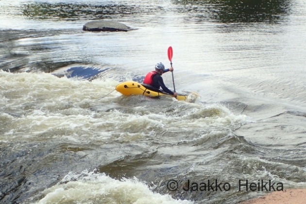
After the hike I went to Ruunaa area at Lieksanjoki. The area is well-known for its whitewater (mainly for one excellent and easy to reach wave for playboating) and fishing. Me and two friends were after the whitewater to test our new MRS Alligator 2S packrafts.
We arrived to the end of the road near Paasikoski rapid around midday, walked to the river, inflated our packrafts and got out for a little test spin. The Alligator was slightly less stable than packrafts with wider tubes but with its six-point rigging it offered tons of control and very agile boating. After feeling confident with the new boats we strapped our packs to the bow and headed down stream.
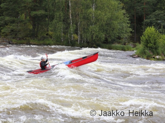
Paasikoski (class 1) was very easy-going. The Haapavitja (class 2) rapid offered little more fun in the form of bigger waves and more speed and was followed by easy going river sections which ended into the Neitijärvi lake. Lake paddling into headwind was hard work as always but it was soon rewarded by the Neitikoski rapid (class 2*). A short, narrow and deep bit with an excellent stopper wave suitable for freestyle kayaking.
We had all done the rapid in the past so decided to go straight thru heading into the big wave to see how the boats would perform. I went first, capsized and took a swim. Huck followed and did the same. Thomas coming as the third decided to take the easier line on the right and stayed upright. We probably did a good impression on the kayaker playing in the wave!

After routine self-rescues we went back to the shore, got rid of our packs and went testing the wave again. Huck tried to get thru the wave with the rucksack on the bow and managed on his third try but capsized in the wave train following the stopper. Me and Thomas concentrated on trying to get into the surf. Thanks to the thigh-straps of the Alligators it was possible but the current was simply too strong for our skills, or for the packraft in general, as once you got into slightly wrong angle or position the rushing water twisted our low-pressure rafts in a way that even agressive bracing didn’t help and swims were inevitable.
But it was still damn fun!


After an hour or so in the Neitikoski we continued down stream paddling Kattilaskoski (class 1) and Murrookoski (class 2) which we scouted for a safe route and also to get warmer as it was raining and our energies were getting low. After Siikakoski (class 1) we took out and camped at one of the many lean-tos on the area. We had a great evening by the campfire enjoying good food, beers, stories and the short night of the summer solstice with a glimpse of the full moon and falling in sleep to the sound of the rushing water.


In the morning we packed our packs and headed upstream enjoying the warmth and sunshine. We decided to take a slightly adventurous shortcut following a little stream to Neitijärvi and crossing the lake to reach a road near the parking area. A nice thing possible with packrafts: you hike, you find a waterway, inflate your raft and follow it. Even though the stream was quite short it added a lot to the trip which could’ve otherwise been done with a canoe or kayak as well. (Leaving the boats down stream to be picked up after walking back to the car.)


The new MRS packrafts worked really well and I’m excited to get more whitewater time with them. Packrafting is so much fun, and packrafting whitewater is even more fun!
I’ll write more about the boats later this summer. Altogether it’s a 4 kg package which, in my opinion, hits the sweet spot between the whitewater performance and the packability and performance for general use. If you want to test them yourself, ask for possibility to rent one or join one of my packrafting courses!
As usual, more pics here.
* These are my estimates on the classic whitewater rating scale based on the water level (138,9m) and discharge (95m^3/s) we had on the trip. The official ratings are little higher, especially for higher water levels. For packrafts the big stopper wave in the Neitikoski difficult but there is a way around if you don’t like the chance of swimming it.
What drives a sane person to shiver non-stop for four days and four nights, while not eating or sleeping and call it a holiday?

Editors note: I’m privilege to have extra-ordinary friends who do amazing things. One of them is Huck, a fellow wilderness guide and founder of NordicByNature. He has earlier written quest posts to my blog and as I heard he had just returned from a four-day solo trip with no food and minimal equipment having witnessed the rather early first snow on the way, I again asked for a trip report to share. And as he is a nice guy, he wrote one. here you go! Huck didn’t carry a camera so all the photos are taken and added by me just to make the layout little lighter. All text by Huck. Also feel free to comment or ask, I’m sure Huck will drop by to answer any questions.
Conditions
Location: Hiidenportti National Park
Time: 20.- 24.9.2014
Duration of Solo: 4 days and 4 nights
Weather: rain, snow, wind, temperatures above and below freezing
Distance covered on one meal: 27km
Rules
– same location all time (10m radius)
– avoid sleeping
– no food
– little water (1-2L)
– minimal gear
(isolation mattress, wool blanket, woolen hat, anorak made of old wool blanket, rain poncho, canteen cup. No other cloth.)
Backup
For safety reasons I took with me:
– shelter (tarp, sleeping bag, extra clothing)
– water (an additional two liters plus the potential to melt snow & collect rainwater)
– food (energy rich food)
– stove & tinder (Picogrill wood stove, plenty of fuel, also fatwood found at the location)
– 1st Aid kit
– fully charged phone, map
Background/ motivation
As a wilderness guide and founder of NordicByNature I am offering nature education and nature awareness programs. In cooperation with the Metsäkartano youth center, I am working on the “Natural transition” project, which is aimed to provide an initiation-opportunity to youngsters on the step to adulthood.
In today’s society, social and biological adulthood are not reached at the same age, as it originally should be the case according to human nature. In addition, we do not experience proper initiation into adulthood anymore and have thus often insufficient understanding of our responsibilities, opportunities and roles as members of the global community.
In many indigenous societies, the importance of initiation is better acknowledged and rituals like solos and other challenges mark the transitional phase in this rite of passage.
As I am very interested in initiation rituals and as an intended facilitator/ guide for initiation, I felt obliged to have experienced more than what I would like to provide to young adults.
Preparations
While the opportunity came unexpected, I had been planning to go for a longer solo ever since my solo in 2013.
A few facts played a role in terms of mental and physical preparation.
Having realized the benefits and logic of barefoot walking, I was basically barefoot ever since the last snow in April this year. I also like to dress just a bit colder than cozy and I usually fast for a few days every month. In general I try to live strictly in “need to have” terms instead of “nice to have”. This considers consumption of energy and resources.
Another part of my preparation is a lifelong interest in survival training and survival skills. I am also interested in the physical and mental aspects of initiation rituals such as solos as well as other challenging situations.
Being trained by Wildmed in Wilderness advanced 1st Aid, I was aware of the potential danger that I was going to put myself in. Hypothermia, Dehydration, other cold-related problems and physical injuries were on the list of anticipated problems. For this reason I asked a friend, who is trained to the higher level of “Wilderness First Responder” to walk me out on the last day, bringing with her more energy rich food and also rubberboots.
Another taken precaution was to choose a location for the solo with phone coverage (up on a hill), even though it meant colder temperatures, more snow and more wind. I also shared my position upon arrival and had agreed to report via sms every morning.
From the medical perspective it was good to have a checklist, with pre-set limits for when I would start using the back-up plan or parts of it. With the list I monitored my mood (level of awareness), urine output, skin colour, dexterity of fingers and toes, pulse, and respiratory rate.
Chronology of events
As I spend most of the time sitting or laying, dreaming and thinking, this journey was truly eventful from a psychological point of view. I learned a lot about myself and the rest of nature and had many thoughts and ideas, which let me recommend such an experience to you.
However, in this post I am not going to write about any of this, as the intention is to focus on the physical challenges.

Saturday, 20.9.
Müesli in Joensuu is the last meal for the next days. After breakfast I pack up my stuff and cycle to the end of town, where I leave my bike locked to a tree, hide the key nearby and start hitchhiking towards Nurmes. I had assumed that hitchhiking in my forest cloth, wearing a sarong and no shoes would be difficult and I was right. On the upside I got more rides by single women, as I probably looked very harmless.
In the evening I arrived in Valtimo and started walking towards Peurajärvi, at the southern end of Hiidenportti Nationalpark. After walking about 16 kilometers into the dark without getting any more rides, I went to sleep in my sleeping bag under a little spruce tree.
The weather of the day was nice and sunny but it was getting cold.

Sunday, 21.9.
For the last bit I got a ride from Thai-berrypickers. The interior of the car was super-heated and the guys inside were wearing balaclavas. They didn’t look happy but seemed amused by my leg-wear.
I had looked up a potential area for the solo on my map and started my hike towards it, which took about 4.5 km. On the way I ate half a “Boletus edulis” and a few berries. Near “Pitkä-Portti” I boiled some water, made some chaga tea and went for a swim, to clean myself for the solo.
Temperatures went further down and the air became more moist.
On the last bit of the journey up the near hill I found more tracks and signs of bears and started to become curious if I would have a chance to see some.
At the lake I had made a strong cup of chaga tea in my canteen cup, which I had carried up the hill, drinking small sips and keeping them in my mouth for hours.
I was now almost naked, only wearing a simple anorak that I had made from an old blanket. The night I spend sitting against a tree (I really know her well now).
Shivering had started shortly after my arrival (must have been around noon) and it continued through the night. It was raining all night long. I sat on my isolation mattress, the ends in front and behind me tucked up under the rain poncho. The wool blanket I had folded double to achieve more isolation at the cost of having to make myself really small to fit under.
By the morning some water had leaked in and I sat in a little puddle on my mattress. There was a lot of condensation and the woolen blanket was moist.

Monday, 22.9.
The rain continued the whole day. I went for three little walks around my area and built up my tarp just in case.
The rain stopped in the afternoon and the wind picked up. I estimated the range of a few dead trees in the area in case they would fall in the wind.
After dark it started to snow. The night was colder and it snowed all night. Again I was at the same spot, but had opened the poncho and used it tucked under the mattress, providing a bit more loose cover.
I had hoped for less condensation due to increase ventilation, but the colder temperatures did not help. The blanket was now more moist but still warm. I use the term “warm” very carefully as I was still shivering. In addition to the cold I was getting very tired at night. The nights were very slow.

Tuesday, 23.9.
Snow everywhere. On Monday I had topped up the tea in my canteen cup with rain water.
To allow my blanket to dry a bit, I sat some time under the tarp. Condensation was a real issue in the night and I consider spending the next night under the tarp, which will be less warm but dryer. I have less motivation to move and I am smelling very different as I am now (I guess) the second day in ketosis.
Night sitting and laying under the tarp. Hipbones painful and I have to choose between pain or being cold, as I can make myself small enough to just fit under the doubled blanket when laying on the side.

Wednesday, 24.9.
I likely have slept a bit since the night went faster than the day or the previous nights. No recollection of sleeping, falling asleep or waking up. In the early morning hours I heard wolves to the east.
It’s still snowing wet and the wind is blowing under the tarp. Worried about the dead trees. The night was colder as expected but less condensation.
When getting up I feel very low on energy. Still peeing about three times per day. Very yellow. So far I have used less than a liter since leaving from the lake.
Happy thoughts let me feel warmer and I decide to be happy. In general I feel in good mood and enjoy the experience. More joy than suffering for sure so far.
In the afternoon my friend comes to check on me. We change a few words and she leaves me a pair of rubber boots for the next day. She will camp 1km away from my location on the way out.

Thursday, 25.9.
Night spend under tarp. Coldest night so far. Frost and cold wind from the north. Hips very painful.
Slush-drizzle in the morning. Drinking the last tea, 2L of backup water still untouched. Feeling cold, weak and tired. I allow myself to write down some notes about the last days. When sitting I feel very clear in my head.
Around midday I am slowly getting ready to leave. After standing up I feel very dizzy and have to sit down again. Packing up is slow but I am taking my time to pack properly. The rubberboots seem too heavy and I decide to walk in my backup-shoes. Studying the map I choose a direct route and try to memorize it.
Walking is very slow. I have to look at the ground (I usually use splatter vision) and even when moving slow breathing through my nose is not enough. Moving through the icy snow hurts my legs. I fall a couple of times and feel frequent need to rest. Somehow I walk down a wrong slope and end up in a wrong place. After realizing my navigation mistake (the first in over ten years), I have to walk one kilometer more to get to my friends camp.
When I arrive at the camp I am pale and dizzy. I drink 2L of warm honey water. My toes are white and without feeling. After melting my toes and resting for about an hour or so and having hydrated, I feel better. Also the sun is coming up for the first time of the solo.
My heart rate at departure from the fireplace while standing stationary: 155 bpm.
The last 3km to my friend’s car are better. Breathing through the nose is again possible and no snow is on the ground.

End of Solo
After a quick shop-stop in Valtimo we continue by car to Puukarin Pysäkki, where I clean myself in the sauna. Exhausting.
The food at Puukarin Pysäkki is known to be the best in North Karelia and I couldn’t think of a better place to be. “Feels like heaven” is humming through my head when I sat down at the table, where locally grown organic food has been skillfully prepared for me. Holiday. I take knife and fork in my hands and immediately get cramps in my fingers. Eating is slow and I wished my appetite were bigger. I somehow manage to eat a fair amount but my thirst is overwhelming. I am drinking liters of water, juice, tea, kotikalja.
Night spend at Puukarin Pysäkki. Next day breakfast and hitchhiking back to Joensuu.
On the journey home I ponder about the effects of the solo and about my symptoms from the previous day:
– Compensated volume shock due to dehydration.
– Mild hypothermia.
– Frostnip on toes and parts of both feet.
I am aware that I came close to some limits and wonder how one more day would have affected me.
Conclusion
I can recommend this experience. Being aware of the medical impact such an experience can have is important, as these weather conditions and the set rules can make some people “sail pretty close to the wind”.
Solo’s can, but do not have to be challenging. If you are looking for a physical and mental challenge, I recommend seeking the advice, preparations and assistance of a trained professional.
Solo’s and “vision quests” have a purpose and it’s not a sport. They have great potential to teach you about yourself, your limits, your strength and your role in life. And in my experience this is exactly what they do.
And this is what drives me.
As I mentioned in the previous post I’ve been doing more overnight trips than usually. About a week ago a good friend of mine, lets call him P, asked if I’d have time for a weekend overnighter to Repovesi National Park. Even though I’ve been living only about an hour’s drive away from the park I’d been there only in winter so I thought it would be about the time to pay a visit in summer as well.
The Repovesi is a small 15 sq km national park located in South-East Finland near Kouvola. (Detailed information is available from the always useful Outdoors.fi pages.) It offers varying terrain, great scenery and good infrastructure: well established trails with good markings, plenty of established camp fire sites, wells for drinking water and some rental shelters. This of course makes the park very popular and often even crowded, something I don’t enjoy much. Our overnighter happened to be on weekend with awesome weather which meant a lot of people but it was also the graduation weekend in Finland which should hold down the hoards of backpackers hitting the park.

After sleeping in way too long on Saturday, doing some last minute shopping and driving to Repovesi me, N and P started the trip in the afternoon from Lapinsalmi parking area. There were quite a lot of cars but no queue to the hanging bridge which was a good sign. We didn’t have a detailed plan, nor a detailed map, for the trip. The general idea was to do a round-trip following the trails towards North and visit all the scenic places on the way, camp somewhere at the end the day and then return to the car the next day.


On the first half of the day we got to enjoy plenty of cumulative height gain as there happens to be quite a lot of rocky hills on the area. Hilltops offered great views on the small lakes and the seemingly endless forests. All hill tops are basically worth a visit when weather is good. At Kuutinkanava (a wooden conduit built for floating logs back in the days when there were logins on the area) we had a nice coffee break (with cake!) utilizing my Bushbuddy stove as open fires were prohibited. After the coffee break we walked some more on trails and occasionally off-trails visiting the tower at Mustalamminvuori hill for some more views before continuing to last major sight on our route, the Olhavanvuori.


Mustalamminvuori tower on the right, Olhavanvuori hill in the middle.

At Olhava we met several groups of topless men with shiny stuff dangling below the waist… And with that, I mean climbers. The 50 meter high vertical walls of Olhavanvuori offer probably some of the best rock climbing in Finland and thus the area is often populated with climbers, especially on a good weekend like this. Rock climbing is only allowed at the Olhavanvuori though the whole park is littered with nice rock faces… We let the climbers keep the vertical stuff and took a detour on top of the hill for some more scenery and a nice break on the top. For most of the day a slight breeze kept the bugs away and made going pleasant. Olhavanvuori is worth a visit even if you’re not a climber. It’s an impressive piece of rock with good views.

Did I mention w-i-d-e trails in the title? This one is actually a road.


Climber populated camping area at the base of Olhavanvuori.
Continuing to North-East from Olhavanvuori we found a scenic camp spot at a small headland called Sukeltajaniemi and as it was already around 8.00 pm we decided to camp there. N stayed at the camp pitching the tent to shelter us from the bugs while me and P walked some 900 meters (one way) to a well at Saarijärvi parking area to refill our water bottles. It was quite obvious we hadn’t drunk enough during the day: nearly +30C and lots of ups and downs calls for a lot of water and I was till in the “winter mode”. Luckily this was easily solved by drinking more.
Back in the camp we prepared a hearty three-course dinners. One of the advantages of light kit is that you can carry quality food – and some wine to go with it. Bruschettas with Spanish style antipasti and read wine turned out to be a great starters also in the woods. I’ll be definitely packing more of that over the summer. For the main course we had some nice slowly cooked soup and to make up the lighter main course we had pancakes with cloudberries and whipped cream. Unfortunately the cream hadn’t liked the heat of the day and immediately turned quite butterish, but was still totally edible. Next time I’ll have to pack it inside the sleeping bag with something cold…The Bushbuddy stove provided an atmospheric little camp fire and also helped to fend of some of the bugs that returned as the wind died.


It doesn’t get darker than this. No need for headlamp.
After staying up late we didn’t set alarms for the morning. And just as expected, the sun woke us up in the morning and the body yearned for a morning swim! (Even with the both ends of the Anjan 3 tent were rolled up, it’s still quite warm in direct sunshine with three people inside.) After a relaxed morning of swims and breakfast it was time to continue.
We followed the trail at the Eastern edge of the National Park South towards Tervajärvi visiting the cool rocky ravine at Kirnukangas. Worth a visit as well. The trails on the Eastern parts are little smaller and less populated but still clear and easy to follow. At Tervajärvi we had one more swim and noticed that N’s Suunto watch had dropped on the way. It was hanging from the shoulder strap of her pack and had probably snagged against a tree and dropped. We backtracked a while trying to look for it but didn’t have luck and returned back to Lapinsalmi crossing the Kapiavesi with a ferry.


All in all, it was yet another great little overnighter with good company, great weather and delicious food. The Repovesi was a positive surprise: it doesn’t have the feel of a real wilderness in it, but the scenery is beautiful and the ups and down offer also some challenge for walking. You can still find peaceful and quiet spots even on the trail side and going off-trail is also allowed and would definitely get you away from the crowds, but also away from the major sights which are all worth visiting. Maybe next time…
– – –
Psst! If you’re confident with your navigation skills and intend to only or mostly follow the trails at Repovesi you can probably get away with just the pdf trail map available for free from here.
– – –
And for those interested, more photos available (for free!) from here!
Jaakko Heikka - Professional wilderness guide and diehard outdoor enthusiast with a special interest for lightweight backpacking, arctic expeditions and outdoor photography.
For more pictures, visit my gallery
